Section 5 KCanG · Berlin
Cannabis no-consumption zones in Berlin
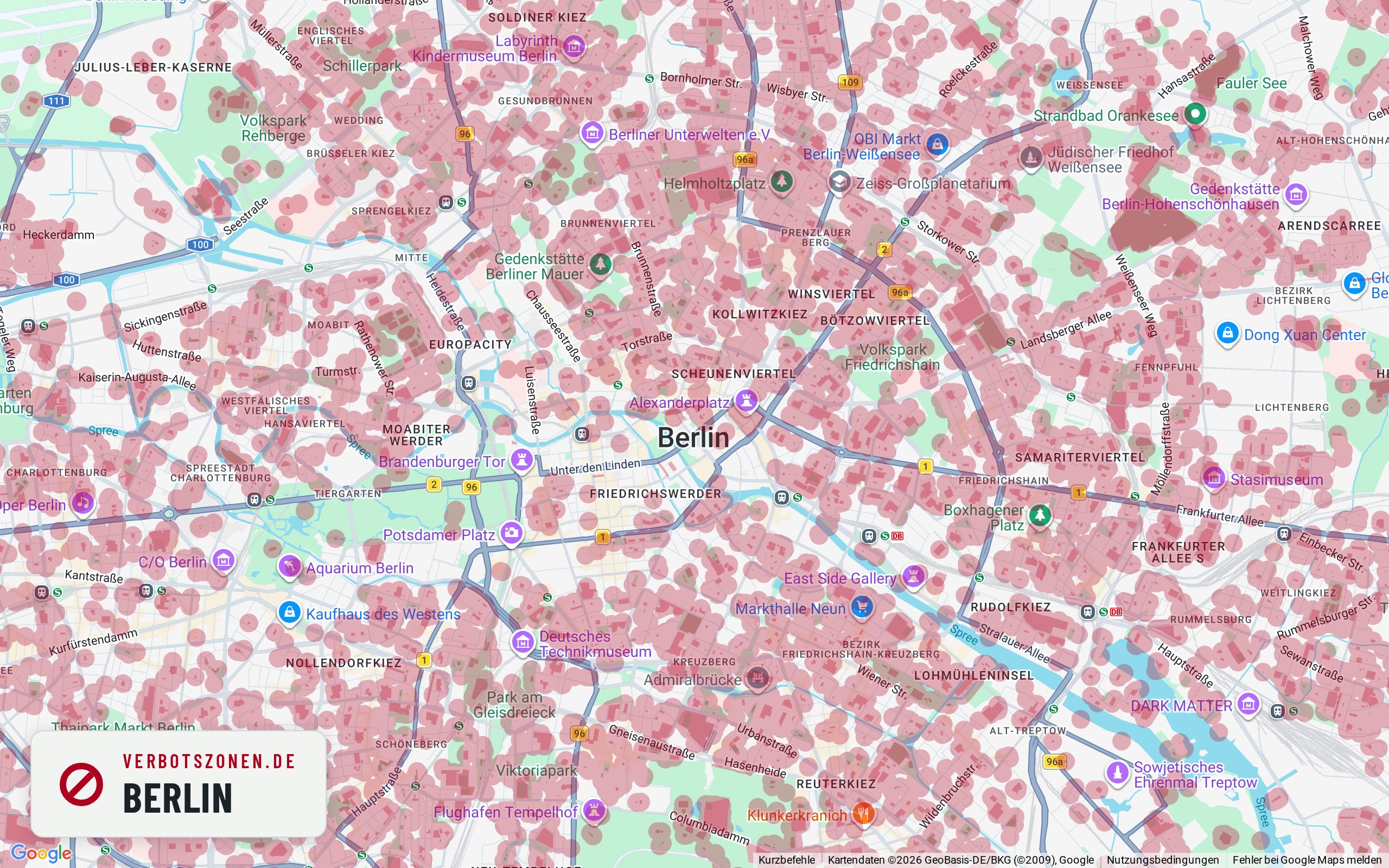
Where can you smoke weed in Berlin – and where can't you? The map below shows every cannabis no-consumption zone in Berlin under Section 5 of Germany's Cannabis Act: schools, children's playgrounds, daycare centers, youth facilities and publicly accessible sports grounds, each with the 100-meter radius around its entrance. On top of that, consumption in pedestrian zones is banned between 7 a.m. and 8 p.m.
No-consumption zones in Berlin on the map

- School
- Kindergarten
- Daycare center
- Playground
- Sports facility
- Other
This map is just the preview – get the full feature set for free in the app.
Well-known places
Well-known places in Berlin: where can you smoke?
Landmark, park or shopping street: this is how we assess well-known places in Berlin under § 5 KCanG – each with its own map extract.
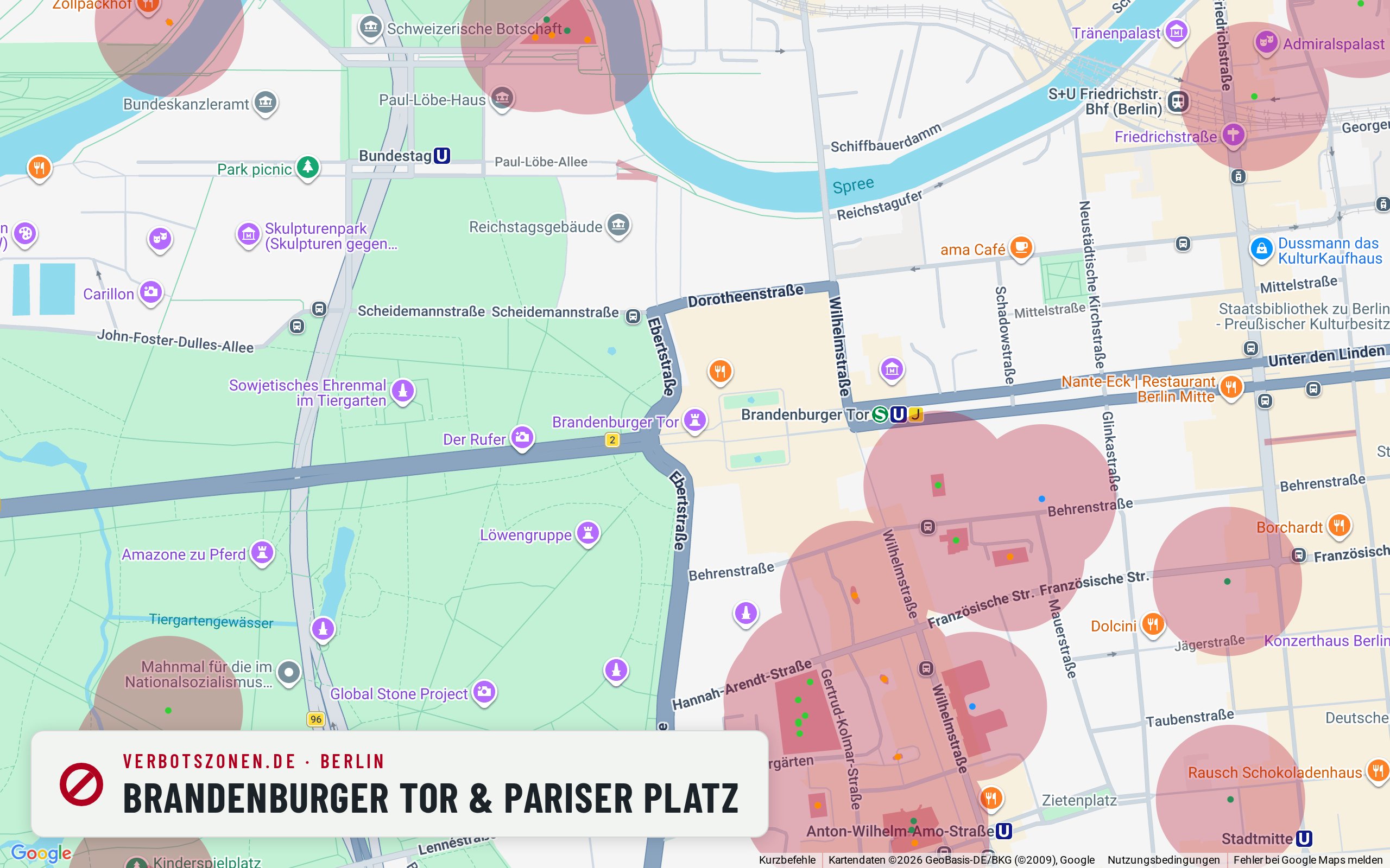
Brandenburg Gate & Pariser Platz
Our map draws no facility zone on Pariser Platz – but the square is a pedestrian area, so the 7 a.m.–8 p.m. window is likely to matter during the day.
The Brandenburg Gate is Berlin’s most photographed address, and Pariser Platz is busy to match. According to our map data there is no school, daycare, playground or sports zone within 300 metres – unusually clear compared with most inner-city locations. What matters instead is the pedestrian-area designation: where a pedestrian zone applies, consumption is prohibited between 7 a.m. and 8 p.m. under § 5(2) no. 5 KCanG. On top of that, tour groups with children are around the gate at practically all hours.
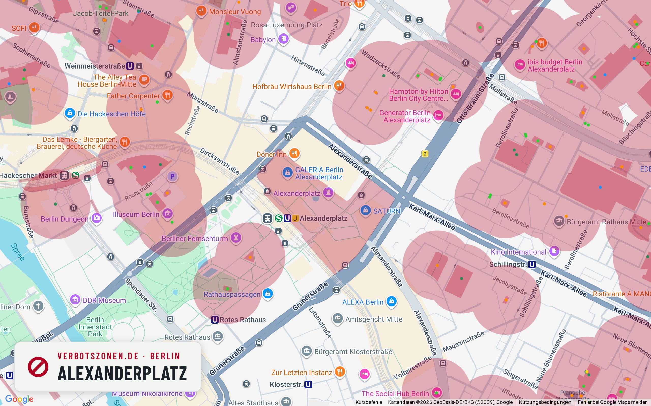
Alexanderplatz
Our map draws no zone on Alexanderplatz itself – the nearest playgrounds sit just outside, so the pedestrian areas and the time of day are likely what count.
TV tower, world clock, station: Alexanderplatz is one of the busiest places in the city. According to our map data the nearest playgrounds are some 270 metres away, so their 100-metre radii do not reach the square itself. Large parts of the Alex are pedestrian areas, though – there the ban runs from 7 a.m. to 8 p.m., and the picture eases in the evening. Walk on and the situation changes quickly in the surrounding streets.
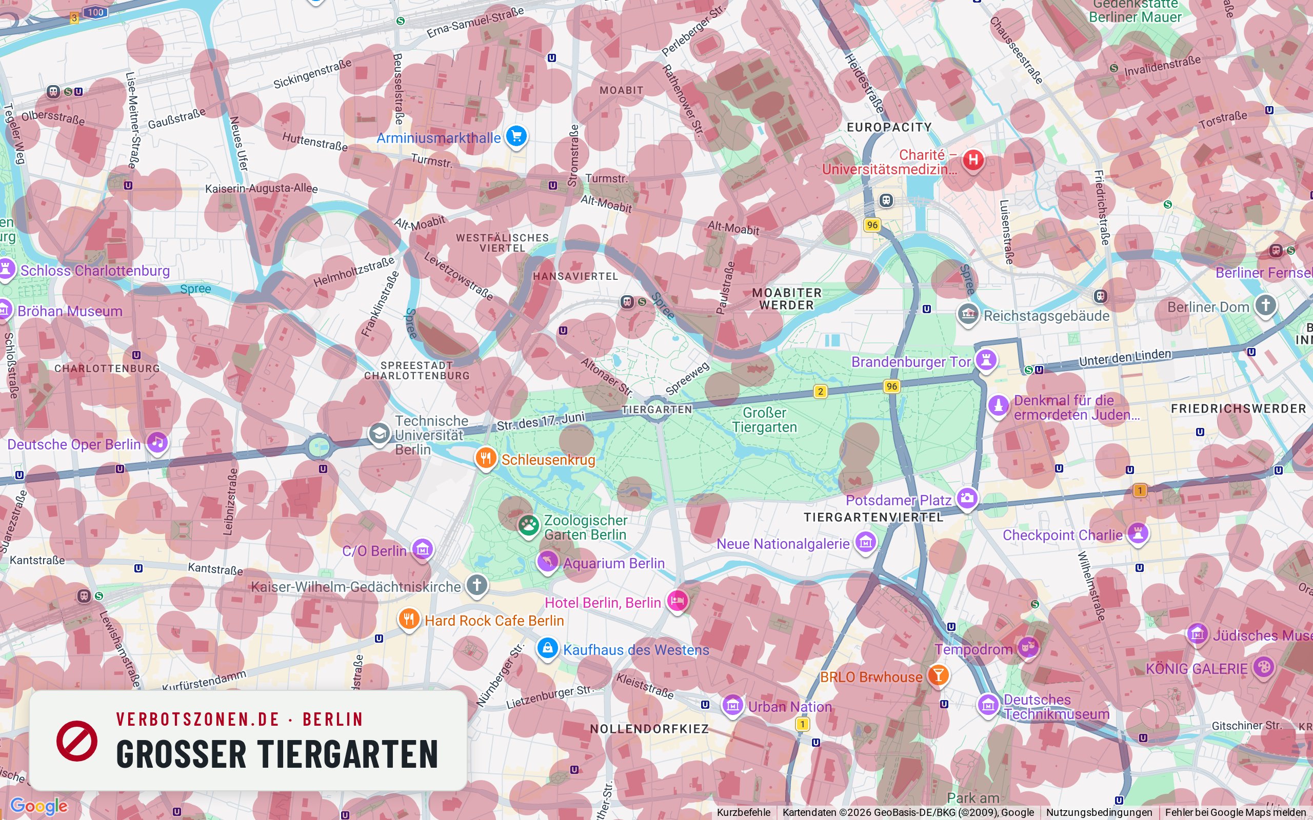
Großer Tiergarten
Across large areas inside the Tiergarten our map draws no no-consumption zone – the facilities sit mostly around the edges.
At over 200 hectares, the Großer Tiergarten is Berlin’s green centre. Parks are not banned across the board under the KCanG, and according to our map data the interior really is largely free of drawn zones: at this map extract the nearest playground is about 270 metres away. The edges are a different story – playgrounds, sports grounds and daycare centres line them with their 100-metre radii. The rule on the immediate presence of minors applies in the park as everywhere else.
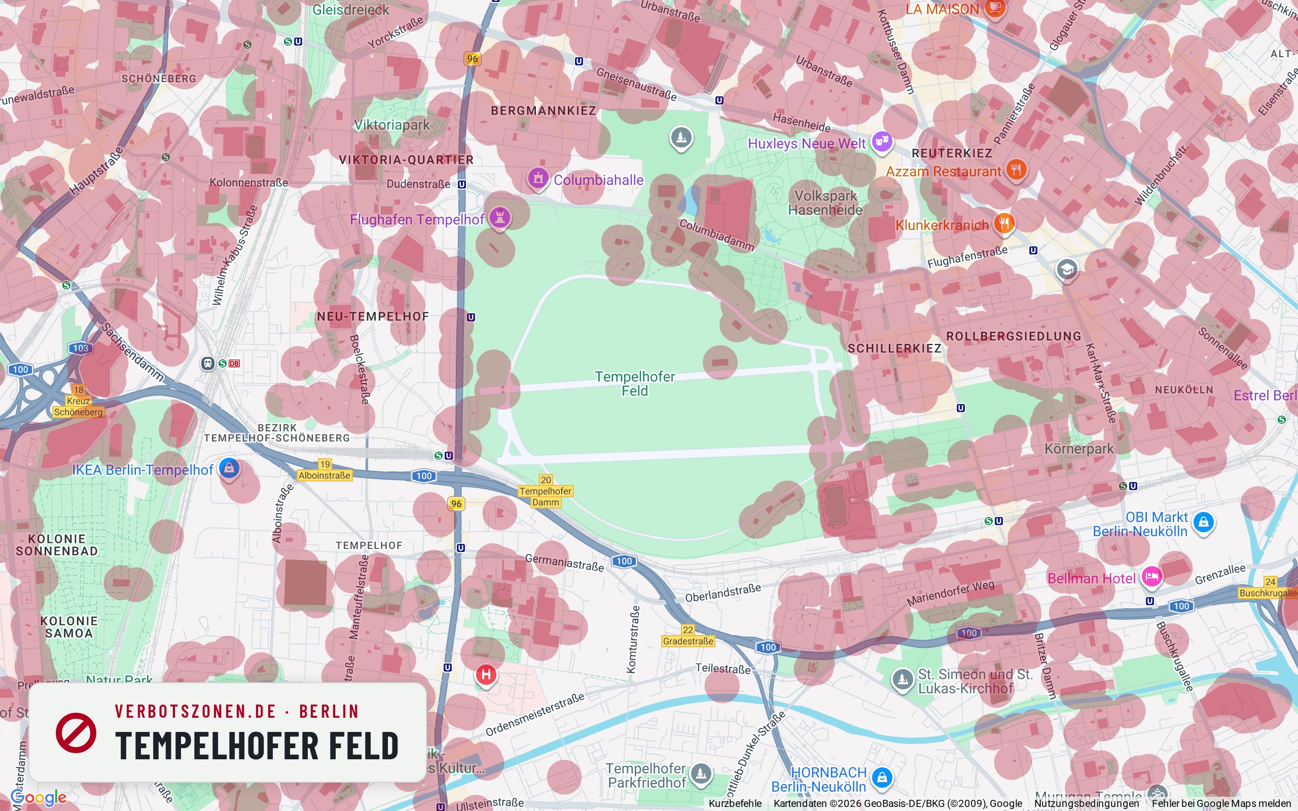
Tempelhofer Feld
Out in the middle of the field our map draws no no-consumption zone – the facilities sit at the entrances and along the edges.
Tempelhofer Feld is Berlin’s largest inner-city open space, and that size is what matters legally: according to our map data there is no recorded facility within 300 metres of the middle of the old runway area. The edges differ – playgrounds, sports areas and youth projects create their own 100-metre zones there, and the edges are exactly where you enter. Note too that the field has its own park regulations, which may impose restrictions independently of the KCanG. On summer weekends it is also full of families.
Mauerpark
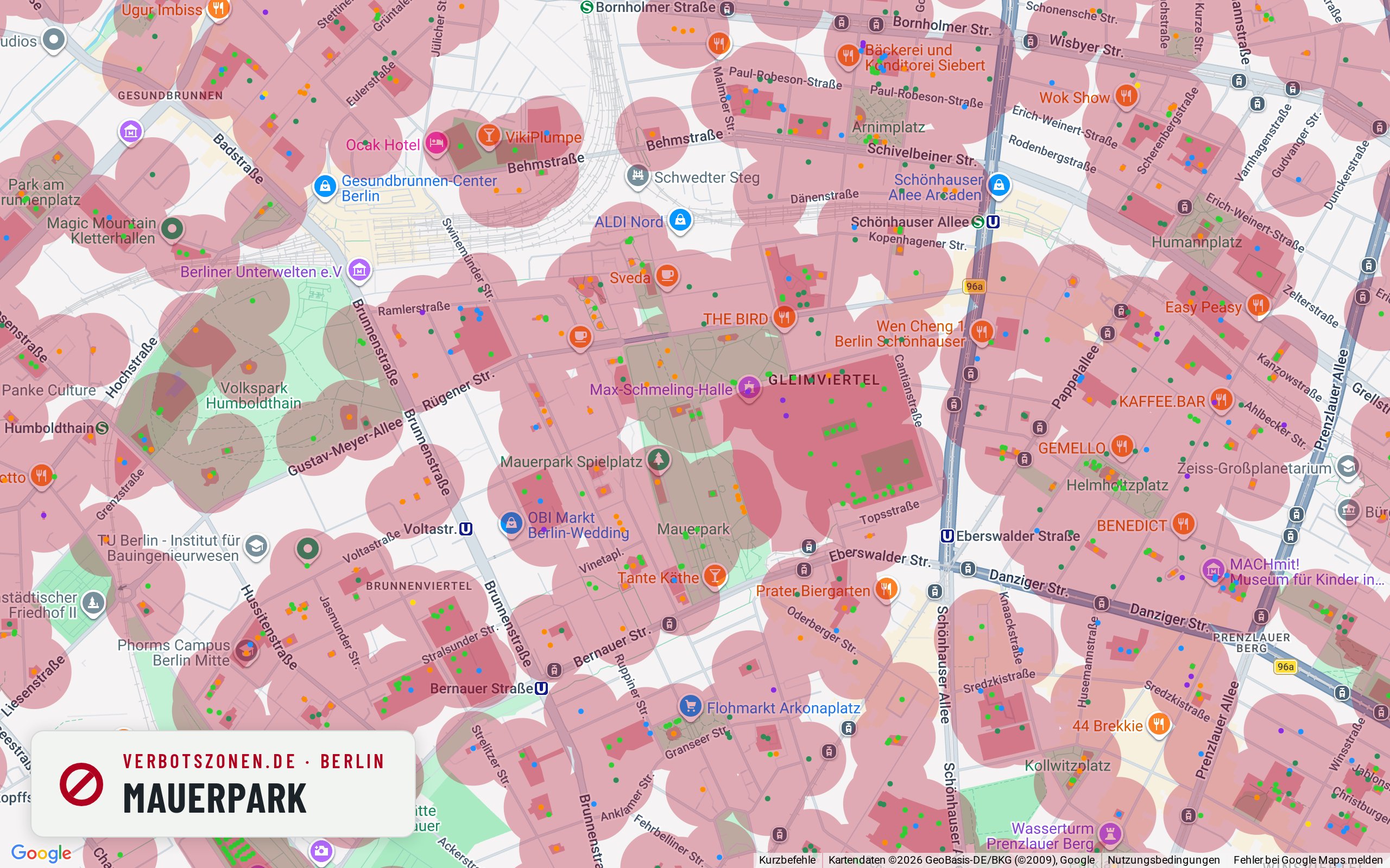
According to our map data the Mauerpark is almost entirely covered by zones – a playground and sports areas sit right in the middle of it.
Sunday flea market, karaoke, packed lawns: the Mauerpark is one of Berlin’s best-known meeting points – and one of its most zone-dense. According to our map data the Regenbogenspielplatz and several sports areas lie less than 80 metres from the centre of the park, and within 300 metres we count more than 30 further facilities. Their 100-metre radii overlap so heavily that barely any zone-free ground is left. On weekends the park is also particularly full of families with children.
East Side Gallery & Spree riverbank
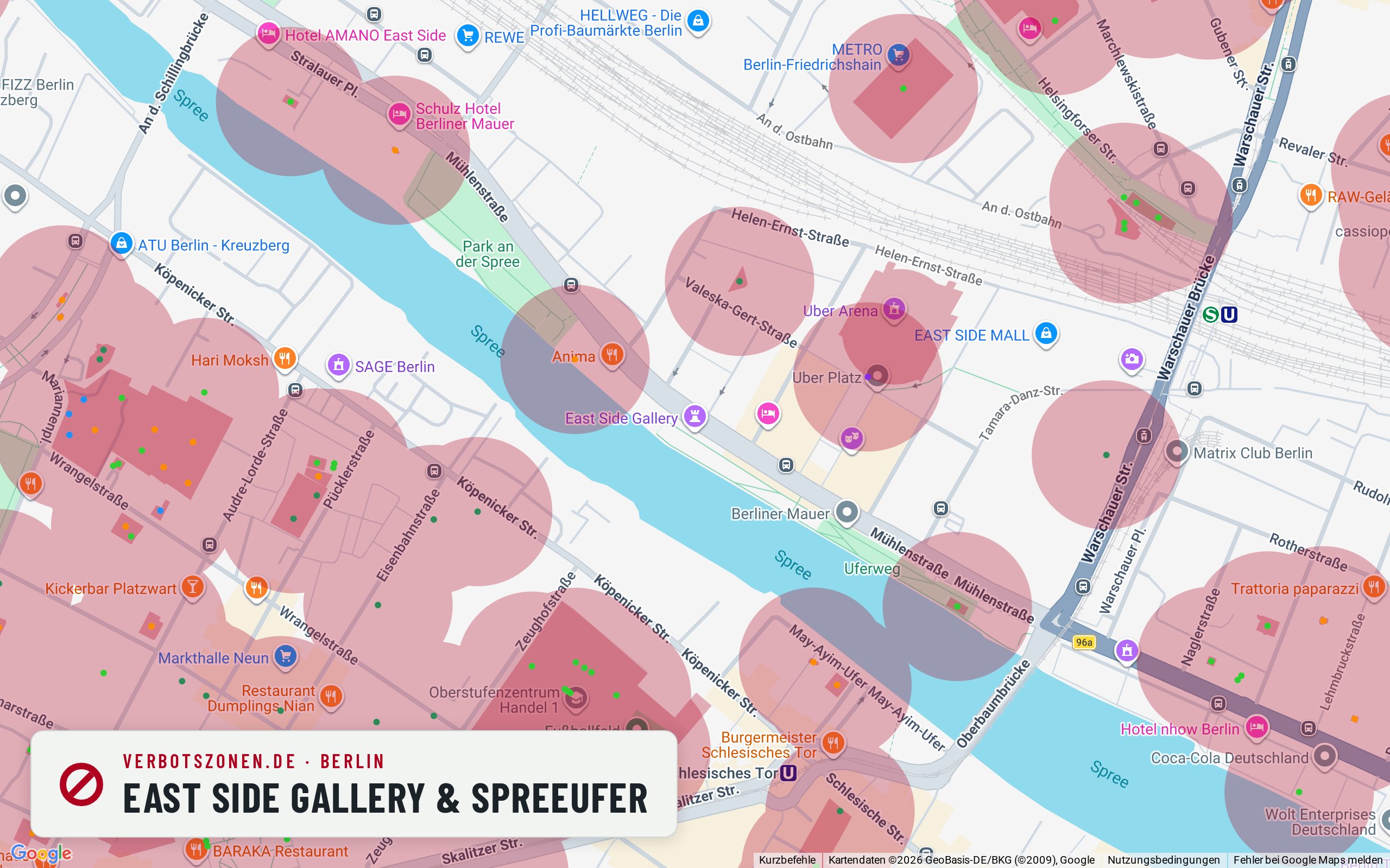
Right along the wall gallery our map draws no zone – but a playground, a daycare centre and the arena grounds come within roughly 200 metres.
The longest surviving stretch of the Wall runs for a good kilometre along the Spree. According to our map data the riverside path itself stays free of drawn zones, but the surroundings are mixed: a playground is about 190 metres away, a daycare centre a good 210, plus the events grounds by the Arena. Head towards Warschauer Straße and the clear stretch ends quickly. Checking the map for your exact spot is especially worthwhile here.
All assessments are based on our current map data and can change at any time – new facilities create new no-consumption zones. What counts is the situation on the ground; the live map above and the app always show the current data.
Data sheet
Berlin's no-consumption zones in numbers
In central Berlin alone, the Verbotszonen App tracks the following facilities that each carry a no-consumption zone:
- 450School
- 1,030Kindergarten
- 47Daycare center
- 1,218Playground
- 1,906Sports facility
- 93Other
- 4,744facilities in total
Figures cover the inner city of Berlin (map extent), data source OpenStreetMap. Each facility creates a no-consumption zone with a 100-meter radius around its entrance.
Pedestrian zones
From what time can you smoke in Berlin? Pedestrian zones and the 7-to-8 rule
In pedestrian zones, cannabis consumption is banned daily between 7 a.m. and 8 p.m. under § 5(2) no. 5 KCanG – from 8 p.m. it is generally permitted there, unless another no-consumption zone applies. What always counts is how the area is designated on the ground. Well-known pedestrian areas in Berlin include:
- Wilmersdorfer Straße
- Altstadt Spandau
- Marzahner Promenade
- Bölschestraße (Friedrichshagen)
Common questions
Smoking weed in Berlin: the rules
Where is cannabis consumption allowed in Berlin?
Consumption is allowed in Berlin anywhere no zone under Section 5 KCanG applies: more than 100 meters from the entrances of schools, playgrounds, daycare centers, youth facilities and sports grounds, outside pedestrian zones during the 7 a.m.–8 p.m. ban, and never in the immediate presence of minors. The map shows every zone in Berlin at a glance.
Can you smoke weed in the Wilmersdorfer Straße pedestrian zone?
Wilmersdorfer Straße is one of the well-known pedestrian areas in Berlin. Where a pedestrian zone is designated, the ban under § 5(2) no. 5 KCanG applies daily between 7 a.m. and 8 p.m. – in the evening and at night consumption is generally allowed there, unless another no-consumption zone applies, such as a school or daycare within sight. Whether an individual stretch is actually designated a pedestrian zone can vary; the signage on the ground is what binds.
How many no-consumption zones does Berlin have?
In central Berlin alone, the Verbotszonen App tracks 4,744 facilities, each creating a no-consumption zone with a 100-meter radius – including 450 schools and 1,218 playgrounds. Across the whole city there are considerably more.
Can you smoke weed in the Tiergarten?
The Tiergarten is big enough that, according to our map data, large areas lie outside any drawn no-consumption zone – a park is not banned across the board under the KCanG. What matters are the facilities: playgrounds, sports grounds and daycare centres, mostly around the edges, each create a zone with a 100-metre radius around the entrance. And regardless of any zone, consuming in the immediate presence of minors is prohibited.
Can you smoke weed in Görlitzer Park?
In Görlitzer Park the picture is considerably tighter than in Berlin’s large parks: within 300 metres of the park’s centre our data records several playgrounds, daycare centres and sports areas, whose 100-metre radii cover much of the ground. The park is also treated as a hotspot and policed accordingly. Anyone who wants certainty should check their exact location on the map.
Always with you
The Berlin no-consumption zones in the app
The map here is only a preview: the free Verbotszonen App shows you live, on the go, which no-consumption zones are near you – in Berlin and all across Germany.


No-consumption zones in other cities
- No-consumption zones in Hamburg
- No-consumption zones in Munich
- No-consumption zones in Cologne
- No-consumption zones in Nuremberg
- No-consumption zones in Augsburg
- No-consumption zones in Stuttgart
- No-consumption zones in Frankfurt
- No-consumption zones in Hanover
- No-consumption zones in Karlsruhe
- No-consumption zones in Dresden
- No-consumption zones in Essen