Section 5 KCanG · Hanover
Cannabis no-consumption zones in Hanover
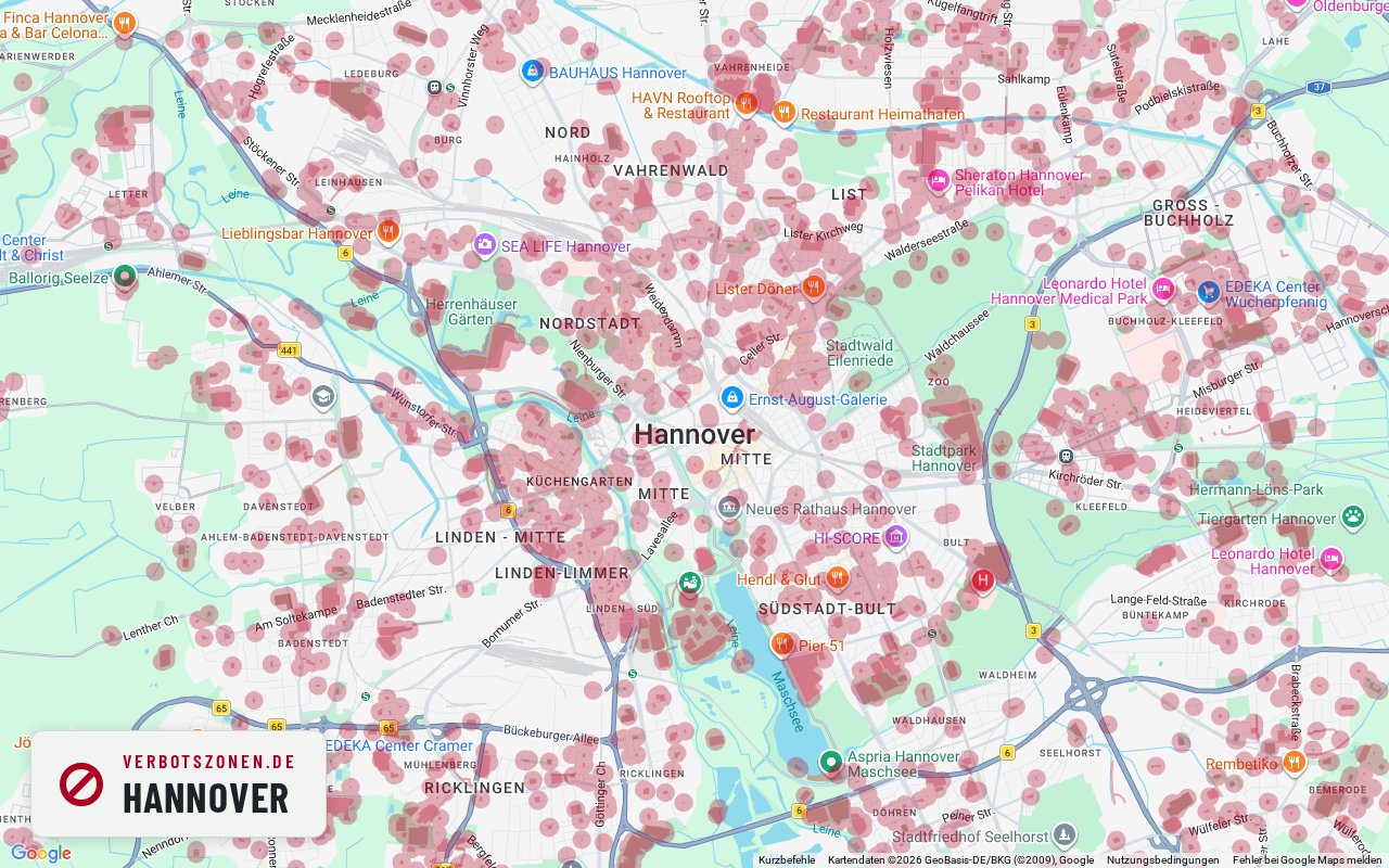
Where can you smoke weed in Hanover – and where can't you? The map below shows every cannabis no-consumption zone in Hanover under Section 5 of Germany's Cannabis Act: schools, children's playgrounds, daycare centers, youth facilities and publicly accessible sports grounds, each with the 100-meter radius around its entrance. On top of that, consumption in pedestrian zones is banned between 7 a.m. and 8 p.m.
No-consumption zones in Hanover on the map

- School
- Kindergarten
- Daycare center
- Playground
- Sports facility
- Other
This map is just the preview – get the full feature set for free in the app.
Well-known places
Well-known places in Hanover: where can you smoke?
Landmark, park or shopping street: this is how we assess well-known places in Hanover under § 5 KCanG – each with its own map extract.
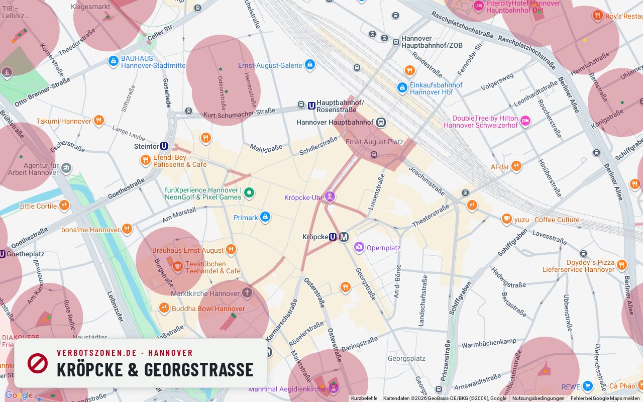
Kröpcke & Georgstraße
Our map draws no facility zone at Kröpcke – so here it comes down almost entirely to the pedestrian zone and the time of day.
Kröpcke is Hannover’s central square and the hub of the inner-city pedestrian zone around Georgstraße. According to our map data there is no recorded school, daycare, sports or playground zone within 300 metres – an unusually clear picture for a main square. That leaves essentially only § 5(2) no. 5 KCanG in play: banned between 7 a.m. and 8 p.m., generally permitted afterwards unless something else applies. The square stays busy in the evening, though.
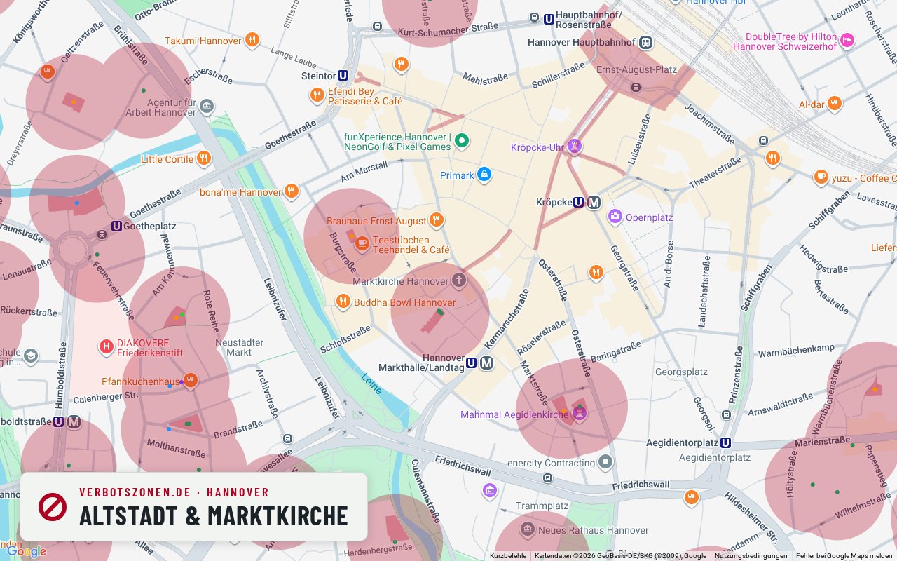
Old town & Marktkirche
Around the Marktkirche our map data puts a daycare centre less than 70 metres away – so the old-town core falls inside a zone.
The rebuilt old town between the Marktkirche and the Leineschloss is Hannover’s historic core, with half-timbering, the Ballhofplatz and pubs. Unlike nearby Kröpcke, the zone picture here is unambiguous: according to our map data a daycare centre by the state parliament lies about 65 to 70 metres from the centre of this extract, and our data counts six daycare entries within 300 metres in total, plus a playground at around 220. Their 100-metre radii apply around the clock and cover much of the old-town core. Some of the lanes are pedestrian areas as well.
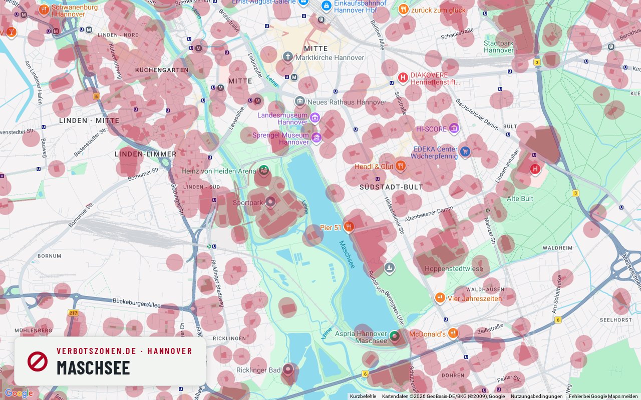
Maschsee
At this point on the Maschsee shore our map draws no zone – a playground and sports grounds start at about 180 metres.
The Maschsee is Hannover’s local recreation area: a shore path, sailing boats, the Maschseefest in summer. According to our map data the stretch of shore chosen here stays clear of drawn zones; the playground at Rudolf-von-Bennigsen-Ufer follows at about 180 metres, with sports areas and the Olympic training centre at 195 and 275. Because a continuous path rings the lake, the picture changes as you walk on – it tightens around the sports grounds to the south. During the Maschseefest, expect a family crowd as well.
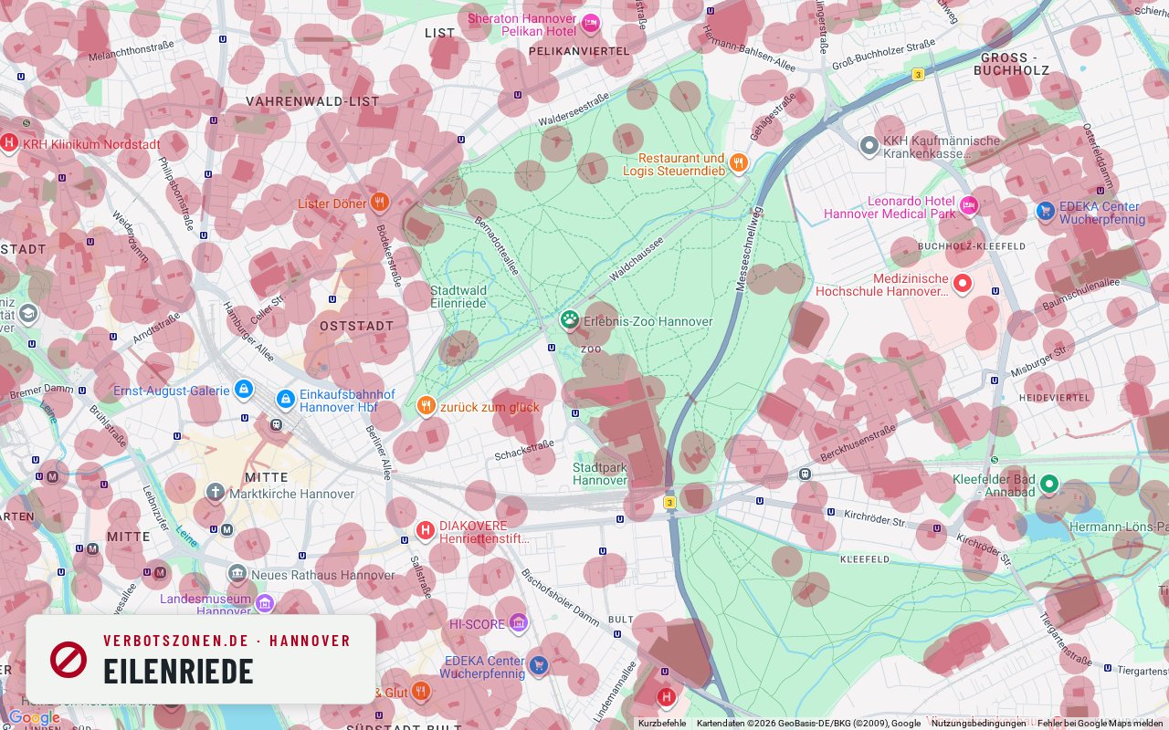
Eilenriede
The city forest is large but not empty: according to our map data there is a playground and 14 sports areas within 300 metres.
The Eilenriede counts as one of Europe’s largest urban forests and looks like one continuous green expanse on the map. That impression is partly misleading: according to our map data a playground lies about 81 metres from the extract chosen here, plus 14 sports areas from around 175 metres – under § 5 KCanG, sports grounds also create a zone with a 100-metre radius. Across the wide wooded areas away from those facilities, our map draws nothing. With a forest this size, checking your exact location is especially worthwhile.
All assessments are based on our current map data and can change at any time – new facilities create new no-consumption zones. What counts is the situation on the ground; the live map above and the app always show the current data.
Data sheet
Hanover's no-consumption zones in numbers
In central Hanover alone, the Verbotszonen App tracks the following facilities that each carry a no-consumption zone:
- 207School
- 533Kindergarten
- 6Daycare center
- 425Playground
- 812Sports facility
- 34Other
- 2,017facilities in total
Figures cover the inner city of Hanover (map extent), data source OpenStreetMap. Each facility creates a no-consumption zone with a 100-meter radius around its entrance.
Pedestrian zones
From what time can you smoke in Hanover? Pedestrian zones and the 7-to-8 rule
In pedestrian zones, cannabis consumption is banned daily between 7 a.m. and 8 p.m. under § 5(2) no. 5 KCanG – from 8 p.m. it is generally permitted there, unless another no-consumption zone applies. What always counts is how the area is designated on the ground. Well-known pedestrian areas in Hanover include:
- Georgstraße
- Bahnhofstraße
- Lister Meile – only the sections designated as pedestrian areas
Common questions
Smoking weed in Hanover: the rules
Where is cannabis consumption allowed in Hanover?
Consumption is allowed in Hanover anywhere no zone under Section 5 KCanG applies: more than 100 meters from the entrances of schools, playgrounds, daycare centers, youth facilities and sports grounds, outside pedestrian zones during the 7 a.m.–8 p.m. ban, and never in the immediate presence of minors. The map shows every zone in Hanover at a glance.
Can you smoke weed in the Georgstraße pedestrian zone?
Georgstraße is one of the well-known pedestrian areas in Hanover. Where a pedestrian zone is designated, the ban under § 5(2) no. 5 KCanG applies daily between 7 a.m. and 8 p.m. – in the evening and at night consumption is generally allowed there, unless another no-consumption zone applies, such as a school or daycare within sight. Whether an individual stretch is actually designated a pedestrian zone can vary; the signage on the ground is what binds.
How many no-consumption zones does Hanover have?
In central Hanover alone, the Verbotszonen App tracks 2,017 facilities, each creating a no-consumption zone with a 100-meter radius – including 207 schools and 425 playgrounds. Across the whole city there are considerably more.
Can you smoke weed at the Maschsee?
According to our map data, much of the Maschsee shore path is not covered by drawn no-consumption zones – a lake or shore path is not banned across the board under the KCanG. The zones come from the facilities around it: the playground at Rudolf-von-Bennigsen-Ufer, several sports grounds and the Olympic training centre, each with a 100-metre radius around its entrance. To the south, around the sports areas, it gets considerably tighter than on the northern shore. And as everywhere: never in the immediate presence of minors.
Always with you
The Hanover no-consumption zones in the app
The map here is only a preview: the free Verbotszonen App shows you live, on the go, which no-consumption zones are near you – in Hanover and all across Germany.


No-consumption zones in other cities
- No-consumption zones in Berlin
- No-consumption zones in Hamburg
- No-consumption zones in Munich
- No-consumption zones in Cologne
- No-consumption zones in Nuremberg
- No-consumption zones in Augsburg
- No-consumption zones in Stuttgart
- No-consumption zones in Frankfurt
- No-consumption zones in Karlsruhe
- No-consumption zones in Dresden
- No-consumption zones in Essen